Setup:
Open marble maps on your computer and select the satellite view with the globe projection.
 To open Marble in the computer lab, in the start menu go to "my computer", open "Local Disk C" (you may need to click on"Show the contents of this folder"), open the "Program Files" folder (you may need to click on"Show the contents of this folder"), open the Marble folder and click on the compass icon to open the program (looks like the picture on the left). You can also download the Marble QT program and install for free on your own computer at http://edu.kde.org/marble/download.phphttp://edu.kde.org/marble/download.php
Open marble maps on your computer and select the satellite view with the globe projection.
To open Marble in the computer lab, in the start menu go to "my computer", open "Local Disk C" (you may need to click on"Show the contents of this folder"), open the "Program Files" folder (you may need to click on"Show the contents of this folder"), open the Marble folder and click on the compass icon to open the program (looks like the picture on the left). You can also download the Marble QT program and install for free on your own computer at http://edu.kde.org/marble/download.phphttp://edu.kde.org/marble/download.phpIntroduction:
Globes are the most accurate way to represent the surface of the Earth. However, you can´t see the whole world on a globe at once, and globes are hard to carry around. To make a flat map makers must figure out how to represent a round map on a flat piece of paper through a map projection.
A map projection is a way of showing the surface of a three-dimensional sphere on a plane. Such projections are necessary to create flat maps.

To understand the projections, it is easier to imagine a light source, a globe, and another geometric object. The light source shines "a shadow" of each point of the globe onto the geometric object. At the end the surface of the geometric object is unrolled, this yields the map.
The problem with projections is that they change the surface in some way; this is called distorsion. Depending on the purpose of the map, some distorsions may be acceptable. For this reason, there are different map projections that serve different purposes.
Distortion
There are 4 types of distortion possible on a flat map.
There are 4 types of distortion possible on a flat map.
- Size (area or square miles)
- Shape
- Distance
- Direction
You are going to look at the distortions in the maps below and compare them with the globe in Marble Map.
Assignment:
Assignment:
Break into groups and on one sheet of paper, put the title of the exercise "Map Projections Exercise", today´s date, and everyones first and last name at the top.
Then below that on the front side of the paper write down:
1) Size and Shape Distortion
2) Distance and Direction Distortion
Then below that on the front side of the paper write down:
1) Size and Shape Distortion
2) Distance and Direction Distortion
Write out comments and notes about what you found while analyzing these distortions in the maps below.
1) Size and Shape Distortion
Compare the sizes and shapes of objects in following maps and with the "globe view" of the world in Marble Maps:
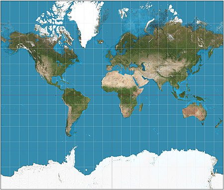
Mercator Projection - was designed for ocean navigation but distorts the size of objects. This distortion increases from the Equator to the poles, where it becomes infinite.

Peters Projection - is an equal-area map where areas of equal size on the globe are also equally sized on the map. But it distorts the size of objects.

Robinson Projection - was specifically created in an attempt to find a good compromise to the problem of readily showing the whole globe as a flat image.
For example> Compare the size of Greenland to Australia on these maps and the globe view of marble maps.

The Mercator projection portrays Greenland as larger than Australia; in actuality, Australia is more than three and a half times larger than Greenland.
2) Distance and Direction Distortion
On the flat Mercator projection map, try to guess which is closest and which is furthest (distance) from Cochabamba to the following places: Sea of Japan, Australia, North Sea, Arabian Sea. Also try to guess what direction you would take to go in the straightest path to get there.
Then, compare this with what you get using the measure feature* in marble maps, try looking at the distance and direction/path between different points on the globe.
*measure feature (Marble allows you to measure distances between two or more points on earth. To do so click the respective points in correct order on the globe using the mouse button. On each click a popup menu will appear which allows you to add a measure point (Add Measure Point) or to remove all measure points altogether (Remove Measure Points). Also try switching between globe projection and flat map projection view in Marble to see where the path goes.
Mercator Projection
Compare the Mercator Projection above and the Gnominic Projection map below. Try to guess what direction you would take to go in the straightest path to get between the following places:
Sea of Japan to the North Sea
Bering Sea to the Black Sea
Los Angeles, California to Cairo, Egypt
Madrid, Spain to Tokyo, Japan
Then, compare this with what you get using the measure feature in marble maps. This will plot a red line that is the straightest path. Then change Marble´s map view to see the path mapped out on a flat map.

Gnomonic Projection - displays all straight lines on a globe (great circles) as straight lines. Thus the shortest route between two locations in reality corresponds to that on the map. Note that because of the extreme size distortion, it cannot show the entire globe at once.
Compare the maps below with the globe view of the world in Marble Maps.
On the flat maps below, try to guess the (distance) from Denver, Colorado to the following places: Sea of Japan, North Sea, Australia, Arabian Sea, Indian Ocean, Antarctica, North Pole. Which is closest and which is furthest away? Also try to guess what direction you would take to go in the straightest path to get there.
Then, compare this with what you get using the measure feature* in marble maps, try looking at the distance and direction/path between different points on the globe. Then change Marble´s map view to see the path mapped out on a flat map.

Azimuthal equidistant projection - Distances and directions to all places are true only from the center point of projection. Distortion of areas and shapes increases dramatically, the further away one gets from center point.

References:
- A detailed discussion of map projections can be found on the USGS Map Projections page.
- A site that allows you to view the world with different map projections.
- A gallery of map projections.
- Map Projection overview, Peter H. Dana.
- Mercator Projection
- Peters Projection
- Robinson projection
- Gnomonic projection
- Azimuthal equidistant projection
- the World according to GARP - azimuthal equidistant map generator
Map Quiz 1
8th Grade Geography - Map Quiz 1 - Thursday January 19, 2012
Using the map on pp. 18-19 of your textbook, please study and memorize the location of the following physical features on the world map: North America, South America, Europe, Africa, Asia, Australia, Antarctica, Pacific Ocean, Atlantic Ocean, Indian Ocean, Arctic Ocean, Mediterranean Sea, Red Sea, Black Sea, North Sea, Caribbean Sea, Gulf of Mexico, Arabian Sea, Sea of Japan, Bering Sea
Please review the definitions of the following terms as they relate to maps:
map key (map legend)
map scale
map projection
compass rose
latitude
longitude
north and south poles
relief
elevation
isoline
No comments:
Post a Comment